
Outsource Geospatial Services
Get access to specialized geospatial services provided by seasoned professionals at prices starting at $12/hour
Transforming businesses, BIM Engineering's strategic, result-oriented, and end-to-end multi-disciplinary geospatial services help organizations with proficient data collection and analysis with the help of powerful digital databases. We help you save time to focus on core activities like innovations and enhanced core operations by integrating Information Technology (IT) and Geographic Information Systems (GIS) to your existing capabilities. BIM Engineering utilizes geospatial technology to offer best-in-class geospatial mapping services and accurate civil engineering solutions to clients, and supports various geospatial data-based business operations.
Backed by 27+ years of providing engineering support services experience and a vision to empower organizations across the globe, BIM Engineering leads the way in using GIS, LiDAR, spatial data conversion, 3D city modeling, geospatial web services, remote-sensing, CAD, Building Information Modeling (BIM), geosimulation and geovisualisation, Terrestrial Laser Scanning (TLS) data processing, cartography, and user-friendly GIS software to meet varied client needs.
Our Geospatial Services
BIM Engineering is a leading geospatial service provider and helps you keep track of projects from start to finish in a highly accurate, reliable, and cost-efficient manner. We help you leverage from our wide range of geospatial solutions to understand project progress and plan out contingencies as required in a more tactical manner. We offer a wide range of geospatial data services along with geospatial data analysis, including –
-
Planimetric Mapping Services

BIM Engineering's experience in digitizing planimetric maps helps us to capture man-made and natural features for widespread GIS solutions at a faster turnaround time at cost-effective rates.
-
Orthophoto Production Services
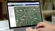
Our Orthophotography and spatial data services give you accurate base maps to enable highly reliable GIS information and similar systems.
-
Photogrammetric Services

We synchronize high-speed imaging and remote sensing to capture exact positions and motion pathways to provide precise location-based mapping.
-
Topographic Mapping Services

BIM Engineering understands the importance of updated and precise topographic maps for businesses that base their decisions on them.
-
Terrain Modeling Services

We combine multiple geospatial mapping techniques to offer you accurate terrain modeling services at low turnaround times.
-
LiDAR Mapping Services
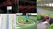
Rely on BIM Engineering for those highly specialized, high resolution LiDAR digital terrain models (DTM) maps to meet your critical requirements.
-
Geographic Information System Services (GIS)
With a high level of proficiency in providing GIS and spatial data management services, BIM Engineering is at the forefront of delivering unmatched GIS services.
-
GIS Surveying Services

By leveraging the latest technology, BIM Engineering offers complete GIS analysis as well as GIS data management to provide highly accurate geographical surveys for varied business needs.
-
Cadastral Mapping Services

Cadastral mapping helps you save the time and money on establishing land ownership by letting BIM Engineering's professionals take care of creating Cadastral maps using AutoCAD, ArcGIS, and more. It enhances the speed of property registration and other processes.
-
Digital Elevation Modeling Services
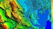
Our DEM services help you get accurate elevation images for various business needs, be it evaluating mass movements of floodplains, terrain slopes, earthquakes, etc.
Other Services You Can Benefit From

Why Choose BIM Engineering as your Geospatial Services Partner?
BIM Engineering is a leading geospatial service providing company and has a specialized team that conducts expert geospatial analysis. Some of the reasons why our clients trust our services are –
-
Cost-effective Prices
We provide our geospatial services at extremely cost-effective prices, enabling you to obtain the most specialized services at great value for money.
-
Superb Infrastructure
We provide our geospatial experts with access to world-class infrastructure, enabling them to perform at optimal levels consistently.
-
Experienced Team
Our team at BIM Engineering is highly experienced and skilled at handling various specializations in geological mapping and is adept at analyzing and delivering results based on various business and industry requirements.
-
Use of Latest Tools
As a leading provider of geospatial services in India and globally, we leverage the most advanced, stable, and latest technologies to deliver best-in-class services to our clients.
-
Accuracy
Our experience in 2D, 3D, CAD, web mapping, and other related technologies helps us deliver more accurate and clearer geospatial services.
-
High-quality Services
Geospatial mapping is an area of expertise where a deep and wide understanding of the various businesses which use them and the specialized technologies that must be leveraged, is the key. This is exactly where seasoned services providers like BIM Engineering can step in to deliver to your precise requirements.
Client Success Stories

BIM Engineering Performed UAV LiDAR Mapping of More than 600 Km of Canadian Railroad
BIM Engineering performed UAV LiDAR mapping of more than 600 km of Canadian railroads at affordable rates and with high accuracy.
Read more
BIM Engineering Provided Radius Mapping to a US-based Land Services Firm
A leading US-based land expedition services firm required high-quality radius mapping services. We provided the best-quality radius mapping services within a quick turnaround time.
Read moreTestimonials
SVP and Co-Founder - Engineering Resource CompanyThe commitment and focus of BIM Engineering's managers and engineers were excellent, surpassing all our expectations
Outsource Geospatial Services to BIM Engineering
Testimonials
The commitment and focus of BIM Engineering's managers and engineers were excellent, surpassing all our expectations
SVP and Co-Founder – Engineering Resource Company More Testimonials »We are a leading provider of geospatial services in India and globally. Leverage our expert resources and global delivery framework to optimize your operations. We help you sort out implementation and operational challenges that impact your business with our specialized geospatial services.
If you have decided on outsourcing geospatial services to India, look no further. Contact us today to learn how our services can transform your business.